My PhD research investigated land-use history and restoration efforts affected biodiversity and ecosystem services in Kibale National Park, Uganda. I worked with McGill University, Makerere University, and the Uganda Wildlife Authority.
Tropical forest restoration

Although it doesn't replace primary forest, secondary forest can help conserve tropical biodiversity and provide important ecosystem services. Trying to restore those species, interactions, processes, and functions to degraded tropical forest is difficult! Long-term restoration research shows that secondary forest sometimes regenerates in unexpected ways, with different species or forest structure, or is stopped altogether.
My doctoral research focused on the ecological processes and patterns associated with restoring tropical forest. I studied how land-use history affected biodiversity and ecosystem services in Uganda's Kibale National Park, the traditional home of the Batooro. I used data on changes in forest composition and structure and animal populations to assess the outcomes of restoration strategies.
My PhD thesis, Conserving and restoring biodiversity and ecosystem services in an African tropical rainforest, is available here.
Recent publications
|
Monitoring tropical wetlands and grasslands using satellite data
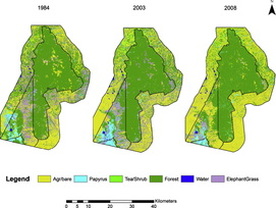
In Uganda, it is difficult for satellites to tell papyrus wetlands from grasslands dominated by "elephant grass". We tested using differences in temperature, topography, and light absorption to separate papyrus and elephant grass in satellite images. We also measured change in six habitat types inside and around Kibale National Park over the last 25 years. Inside the park, reforestation decreased grasslands, while papyrus areas were more or less stable. Outside the park, elephant grass and papyrus decreased by 61% and 39%, mostly from conversion to agriculture and especially in recent years. Our method and findings will help local researchers and managers monitor and conserve wetlands and grasslands. Published in ISPRS Journal of Photogrammetry and Remote Sensing. |

Changes in primate group sizes
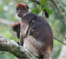
We studied the stability of group sizes for seven primate species over 15 years to see how they changed. We wanted to know if food availability affected group sizes, so we also looked at changes in the size and species composition of food trees. Group sizes did not change for most primate species, except red colobus monkeys. Food availability appeared to have increased in recent years, although trends differed by primate species (also here for more forest data).
Many things could influence group sizes, including predation and disease - it is puzzling that red colobus group sizes changed but other species didn't. Food availability may be an important driver while predation and disease appear to play a lesser role, but understanding the dynamism of this ecosystem warrants further investigation. Published in Biotropica.
With help from the Wildlife Conservation Society-Tanzania, I wrote a summary of this research in KiSwahili, the lingua franca of East Africa.
Many thanks to funding and research partners:
Useful grey literature and graduate theses for researchers working in western Uganda
A Dropbox folder of graduate student theses and grey literature about Kibale National Park and Ugandan forests, and Rutooro language resources.
Other groups, research projects, and NGOs in Kibale
- Bigodi Wetlands Sanctuary and Women's Group
- Kibale Chimpanzee Project
- Kibale Health and Conservation Project built a medical clinic at the gates to the national park and operates a mobile clinic
- Kibale Mobile Clinic is a retrofitted ambulance that travels to remote communities around Kibale National Park, Uganda
- Makerere University Biological Field Station (MUBFS) is the main research centre based in Kanyawara
- Ngogo Chimpanzee Project
- The Chorus of Kibale, a children's book by Eric Losh (a successful Indiegogo campaign)
- Uganda Wildlife Authority (UWA) manages all national parks in Uganda and operates chimpanzee tracking tours in Kibale
- The Wildlife Conservation Society's Albertine Rift Program


